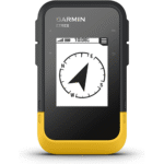

Garmin GPSMAP 67 Handheld
KSh 72,999.00 Original price was: KSh 72,999.00.KSh 64,500.00Current price is: KSh 64,500.00.
- 3” sunlight-readable color display.
- 180 hours of battery life in GPS mode and up to 840 hours in expedition mode.
- GNSS support.
- Vivid satellite imagery
Garmin GPSMAP 67 Handheld in Kenya
Garmin GPSMAP 67 Handheld Price in Kenya is Ksh 64,500. Explore the great outdoors with the rugged, high-quality Garmin GPSMAP 67 Series handhelds. They offer multiband technology and advanced GNSS support for greater accuracy in steep terrain, narrow urban canyons and dense forests. You’ll always have your route in view on the 3-inch color display, which is easy to read even in low-light conditions. The GPSMAP 67 series has ABC sensors (barometer and compass), pre-installed routable TopoActive Europe maps and access to satellite images.In connection with your smartphone you get Smart Notifications weather updates, Geocaching Live data directly on the device and use the Garmin Explore ™ app. The GPSMAP 67 offers you a battery life of up to 180 hours in GPS mode and up to 840 hours in expedition mode.Buy Garmin GPSMAP 67 Handheld online at best price in Kenya at Starmac.
The highlights of the Garmin GPSMAP ® 67 series
- MIL STD 810G approved GPS handheld with 3″ color display
- Improved battery life
- Advanced Multi GNSS support
- Reliable sensors: 3 axis compass, barometric altimeter, Quad Helix antenna
- Waterproof according to IPX7
- ANT+, Bluetooth, WLAN, compatible with re-sighting devices
- TracBack , waypoint and route navigation
- LED flashlight with SOS signal function
- USB C compatibility and expandable memory
- Compatible with Garmin Explore App and Messenger App
Features
MULTI GNSS
Thanks to multiple global satellite systems (GPS, GLONASS, Galileo, BeiDou , QZSS) and multi-frequency technology, positioning is absolutely precise
BATTERY LIFE
The GPSMAP 67 offers up to 180 hours of battery life in GPS mode, up to 840 hours in expedition mode, up to 165 hours of 10-minute tracking in inReach mode, and up to 425 hours in expedition mode
PRECISE NAVIGATION
Automatically calibrates the barometric altimeter and 3-axis electronic compass to always provide the most accurate data available
ABC SENSORS
Automatically calibrates the barometric altimeter and 3-axis electronic compass to always provide the most accurate data available
SATELLITE IMAGERY
Download high-resolution satellite imagery directly to your device via Wi Fi® technology. Effortlessly find trails, search for stands and parking lots, create waypoints and much more
PREINSTALLED MAPS
Preloaded TopoActive Europe maps show you peaks, parks, coastlines, rivers, lakes and geographic points. Garmin Topo maps, CustomMaps , BirdsEye and City Navigator are also compatible with the GPSMAP 66 series
GARMIN EXPLORE
Use the Garmin Epxlore website or app for navigation, waypoints, routes, activities and collections. Plan your next trip by downloading maps and creating routes
GEOCACHING LIVE
Get automatic cache updates from Geocaching Live, including descriptions, logs and hints. When connected via Wi Fi technology or with the Garmin Explore ™Smartphone app, every find is uploaded to your Geocaching.com profile
ACTIVE WEATHER
When connected with the Garmin Explore TM app, you can get real-time weather forecasts
SHARE YOUR LOCATION
Share your location with friends and family from anywhere. Your loved ones at home can also ping your device to get your exact GPS location.
Product Features
- Product dimensions: 6.2 x 16.3 x 3.5 cm
- Display size (W x H):3.8 x 6.3 cm (76 cm diagonal)
- Display type: Transflective TFT display
- Display resolution: 240 x 240 pixels
- Satellite network: GPS, GLONASS, Galileo, IRNSS, QZSS
- Preloaded maps: TopoActive Europe
- Connectivity: BLE | ANT+ | WLAN
- Water resistance: IPX7
- Battery type: Li Ion
- Battery life:
-
- GPS mode / 10 minute tracking: Up to 180 hours
- Expedition mode: Up to 840 hours
-
Color
- black/olive
Weight
- 230 g (manufacturer specification)
Scope of delivery
- Garmin GPSMAP ® 67 Series
- USBC charge/sync cable
- Carabiner
- Documentation
MAECENAS IACULIS
Vestibulum curae torquent diam diam commodo parturient penatibus nunc dui adipiscing convallis bulum parturient suspendisse parturient a.Parturient in parturient scelerisque nibh lectus quam a natoque adipiscing a vestibulum hendrerit et pharetra fames nunc natoque dui.
ADIPISCING CONVALLIS BULUM
- Vestibulum penatibus nunc dui adipiscing convallis bulum parturient suspendisse.
- Abitur parturient praesent lectus quam a natoque adipiscing a vestibulum hendre.
- Diam parturient dictumst parturient scelerisque nibh lectus.
Scelerisque adipiscing bibendum sem vestibulum et in a a a purus lectus faucibus lobortis tincidunt purus lectus nisl class eros.Condimentum a et ullamcorper dictumst mus et tristique elementum nam inceptos hac parturient scelerisque vestibulum amet elit ut volutpat.
Related products
Mibro Lite Smart Watch
Apple Watch SE (2022)
- Always-On Display
- Blood oxygen reader
- New skin temperature sensor
- Multi-sport workouts
- 18 hours battery life
Oraimo OSW-23N Smart Watch R
Mibro Watch X1
Xiaomi MI IMILAB KW66 Smartwatch
Garmin Forerunner 745
- Up to 1 Week of Battery Life
- GPS, GLONASS & Galileo Tracking
- Wrist-Based Heart Rate Monitor
- Wrist-Based Pulse Ox Sensor
- View Your VO2 Max Score
- Built-In Sports Profiles
- Water Resistant Up to 164'
- Receive Email, Texts & Other Alerts
- Contactless Payments with Garmin Pay
- Stream Music or Play from Watch
Garmin Forerunner 645
- Easily download up to 500 songs to your watch, and connect with Bluetooth® headphones (sold separately) for phone-free listening
- Syncs music from select streaming services for offline listening¹
- Garmin Pay™ contactless payment solution² lets you make convenient payments with your watch, so you can leave your cash and cards at home
- Provides advanced running dynamics³, including ground contact time balance, stride length, vertical ratio and more
- Uses wrist-based heart rate4 to offer performance monitoring features, including evaluating your current training status
- Battery life5: up to 7 days in smartwatch mode; 5 hours in GPS mode with music


